Motorhome stops by place › Canada › British Columbia

Whistler: motorhome stops and campsites – Squamish

In Whistler (British Columbia, Canada) there are 3 motorhome stops, 54 campsites, 2 motorhome parkings and 2 rest areas. Here they are, with what we know about electricity, water, waste disposal and what others think. Everything is also on the map, where you can add the places to a trip.

🚐 Plan a trip here 🗺️ Show on map 🌤️ Weather in Whistler
🚐 3 motorhome stops 🏕 54 campsites 🅿️ 2 motorhome parkings 🛻 2 rest areas
Birkenhead Lake Provincial Campsite

🏕 Birkenhead Lake Provincial Campsite

Campsite · 53.6 km from Whistler

Nestled within a scenic regional district in British Columbia, Canada, this campsite provides a quiet rural escape for travellers seeking an overnight stop in the Area C region. Offering basic facilities, including essential toilets, it serves as a …

🚻 Toilet
Show on map →
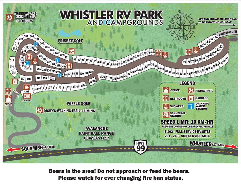
Whistler RV Park and Campgrounds

🏕 Whistler RV Park and Campgrounds

Campsite · 14.6 km from Whistler

Whistler RV Park and Campgrounds in British Columbia, Canada, offers a convenient overnight stop with essential amenities. Caravans and tents are welcome, and WiFi keeps you connected. Surrounded by the scenic landscapes of the Squamish-Lillooet Regional …

📶 Wi-Fi🐕 Dogs welcome
Show on map →
Callaghan Lake

🏕 Callaghan Lake

Campsite · 18.2 km from Whistler

Nestled within a rural regional district in British Columbia, Canada, this campsite offers a nature-filled escape by a lake. The surrounding area provides a scenic and quiet environment, making it a highly suitable overnight stop for travellers exploring the …

Show on map →
Upper Joffre Lake Campground

🏕 Upper Joffre Lake Campground

Campsite · 42.5 km from Whistler

Located in a rural regional district in British Columbia, this campsite offers a peaceful natural setting surrounded by wilderness. It serves as a highly suitable overnight stop for travellers exploring the area, providing a quiet place to rest amidst the …

Show on map →
Seton Dam Campground

🏕 Seton Dam Campground

Campsite · 92.8 km from Whistler

If you are touring Canada in a caravan, Seton Dam Campground provides a convenient overnight stop where caravans and tents are both permitted. Enjoy a restful pause at this British Columbia destination before continuing your journey.

Show on map →
Fraser Cove Campground

🏕 Fraser Cove Campground

Campsite · 99.3 km from Whistler

Set in the heart of British Columbia's dramatic regional district, Fraser Cove Campground provides a convenient overnight stop for travellers exploring Canada's rugged landscapes. Relax with on-site WiFi, making it a practical and comfortable base for your …

📶 Wi-Fi
Show on map →
Nairn Falls Campground

🅿️ Nairn Falls Campground

Motorhome parking · 22.4 km from Whistler

Nestled in a scenic rural valley within British Columbia's regional district, this overnight stop caters perfectly to caravan travellers seeking a convenient place to rest. The campground accommodates both caravans and tents, offering a straightforward, …

Show on map →
Map: Riverside Resort Campground

🚐 Riverside Resort Campground

Motorhome stop · 2.5 km from Whistler

Riverside Resort Campground is a caravan site located in Whistler, Squamish-Lillooet Regional District, British Columbia, Canada. Set right in the Coast Mountains, the Whistler area offers immediate access to alpine hiking and mountain biking trails, with …

🚻 Toilet📶 Wi-Fi
Show on map →
Map: Wedgemount Lake Campground

🏕 Wedgemount Lake Campground

Campsite · 11.5 km from Whistler

Wedgemount Lake Campground sits in Area C of the Squamish-Lillooet Regional District near Pemberton. This backcountry spot lies beside striking turquoise Wedgemount Lake, surrounded by the rugged peaks of the Garibaldi Ranges and the shifting Wedgemount …

🚻 Toilet
Show on map →
Map: Squamish-Elaho Recreation Site

🏕 Squamish-Elaho Recreation Site

Campsite · 31.4 km from Whistler

The Squamish-Elaho Recreation Site is a campsite located in Area D (Elaho/Garibaldi) of the Squamish-Lillooet Regional District in British Columbia, Canada. The site sits along the Elaho River, surrounded by dense old-growth forests and rugged peaks of the …

🚻 Toilet
Show on map →
Map: Riverside Resort Campground

🚐 Riverside Resort Campground

Motorhome stop · 2.4 km from Whistler

Riverside Resort Campground is a caravan site in Whistler, Squamish-Lillooet Regional District, British Columbia. It sits amid the Coast Mountains, where dense evergreen forests flank the Fitzsimmons River. Visitors can hike the alpine trails on Whistler and …

Show on map →
Map: Riverside Resort Campground

🏕 Riverside Resort Campground

Campsite · 2.5 km from Whistler

Riverside Resort Campground is a stop in Whistler, Squamish-Lillooet Regional District, British Columbia, Canada. It sits in a valley defined by the peaks of the Coast Mountains. Visitors can observe black bears foraging in the surrounding forest or bike …

Show on map →
Map: Riverside Dispersed Camping

🏕 Riverside Dispersed Camping

Campsite · 7.9 km from Whistler

Riverside Dispersed Camping is a campsite in Area C of the Squamish-Lillooet Regional District, British Columbia, within the Pemberton Valley/Mount Currie/D'Arcy region. The Pemberton Valley stretches between the rugged Coast Mountains, offering clear views …

Show on map →
Map: Cheakamus Lake Campground

🏕 Cheakamus Lake Campground

Campsite · 10.1 km from Whistler

Cheakamus Lake Campground is a stop in Area D (Elaho/Garibaldi), Squamish-Lillooet Regional District, British Columbia, Canada. It sits at the edge of Cheakamus Lake, a turquoise glacial lake ringed by old-growth forest and the towering peaks of Garibaldi …

Show on map →
Map: Cal Cheak North Camp

🏕 Cal Cheak North Camp

Campsite · 11.4 km from Whistler

Cal Cheak North Camp is a campsite located in Whistler, within the Squamish-Lillooet Regional District of British Columbia, Canada. It sits right near the confluence of the Cheakamus and Callaghan Rivers, where visitors can watch rushing glacier-fed waters …

Show on map →
Map: Cal Cheak Callaghan Camp

🏕 Cal Cheak Callaghan Camp

Campsite · 11.7 km from Whistler

Cal Cheak Callaghan Camp is a campsite located in Whistler within the Squamish-Lillooet Regional District of British Columbia, Canada. It sits near the Callaghan Valley, where dense forest and rugged mountains define the landscape. Visitors can explore the …

Show on map →
Map: Cal Cheak Central Camp

🏕 Cal Cheak Central Camp

Campsite · 11.8 km from Whistler

Cal Cheak Central Camp is a campsite located in Whistler, British Columbia. It sits right at the confluence of the Cheakamus and Callaghan Rivers, surrounded by the towering peaks of the Coast Mountains. From this riverside spot, you can wade in glacier-fed …

Show on map →
Map: Cal Cheak South Camp

🏕 Cal Cheak South Camp

Campsite · 12 km from Whistler

Cal Cheak South Camp is a campsite located in Whistler, British Columbia. It sits right along the Cheakamus River, offering immediate access to the valley's rugged river landscape. Campers can watch the glacier-fed waters rush by, hike the nearby Cheakamus …

Show on map →
Map: Singing Creek Campground

🏕 Singing Creek Campground

Campsite · 12.1 km from Whistler

Singing Creek Campground is located in Area D (Elaho/Garibaldi) in the Squamish-Lillooet Regional District of British Columbia, Canada. It sits deep in the Elaho Valley, where dense old-growth forests of Douglas fir and western red cedar line the rugged Elaho …

Show on map →
Map: Russet Lake Campgrounds

🏕 Russet Lake Campgrounds

Campsite · 12.1 km from Whistler

Russet Lake Campgrounds sits in Area C of the Squamish-Lillooet Regional District near Pemberton, surrounded by the rugged peaks of the Coast Mountains. The alpine setting puts you right at the base of the Spearhead Range, where hiking routes climb toward …

Show on map →
Map: Hideaway

🏕 Hideaway

Campsite · 29.8 km from Whistler

Hideaway is a campsite in Area D (Elaho/Garibaldi), Squamish-Lillooet Regional District, British Columbia, Canada. This location places you at the edge of the rugged Coast Mountains, where the Elaho River carves through valleys of ancient Douglas fir and …

Show on map →
Map: Strawberry Point Recreation Site Campground

🏕 Strawberry Point Recreation Site Campground

Campsite · 35.1 km from Whistler

Strawberry Point Recreation Site Campground sits in Area C of the Squamish-Lillooet Regional District, set against the dramatic rise of Mount Currie in the Pemberton Valley. The site occupies a small peninsula jutting into Lillooet Lake, where the Lillooet …

Show on map →
Map: Chain Lakes

🏕 Chain Lakes

Campsite · 35.1 km from Whistler

Chain Lakes is a campsite in Area C of the Squamish-Lillooet Regional District in British Columbia, near Pemberton Valley, Mount Currie and D'Arcy. It sits in a rugged transition zone where the lush Pemberton Valley meets the dry rain shadow of the Coast …

Show on map →
Map: Lizzie Bay Campsite

🏕 Lizzie Bay Campsite

Campsite · 35.9 km from Whistler

Lizzie Bay Campsite is located in Area C of the Squamish-Lillooet Regional District in British Columbia, Canada. It sits near the eastern end of Anderson Lake, where steep, tree-covered mountains plunge directly into the cold, deep water, and the BC Rail line …

Show on map →
Map: Twin One Creek Recreation Site

🏕 Twin One Creek Recreation Site

Campsite · 36.2 km from Whistler

Twin One Creek Recreation Site is a campsite in the Squamish-Lillooet Regional District near Pemberton and D'Arcy in British Columbia. The Lillooet River flows nearby through the wide Pemberton Valley, with Mount Currie rising sharply above the farmland to …

Show on map →
Map: Lillooet Lake Lodge

🚐 Lillooet Lake Lodge

Motorhome stop · 36.6 km from Whistler

Lillooet Lake Lodge is a caravan site in Area C of the Squamish-Lillooet Regional District. The site sits near the town of Mount Currie at the southern end of Lillooet Lake, where the glacier-fed Lillooet River widens before spilling into the larger river …

Show on map →
Map: Fowl Lake

🏕 Fowl Lake

Campsite · 37.1 km from Whistler

Fowl Lake campsite is located in Area C of the Squamish-Lillooet Regional District in British Columbia, Canada. The waters here sit against the dramatic backdrop of the rugged Coast Mountains, with Mount Currie rising sharply nearby. You can observe the dense …

Show on map →
Map: Upper Fowl Lake

🏕 Upper Fowl Lake

Campsite · 38.2 km from Whistler

Upper Fowl Lake is a campsite in the Pemberton Valley/D'Arcy area of the Squamish-Lillooet Regional District where tents are allowed. Set near the headwaters of the Birkenhead River, it offers access to Lillooet River backcountry channels and old-growth …

Show on map →
Map: Lizzie Lake Recreation Site

🏕 Lizzie Lake Recreation Site

Campsite · 40.6 km from Whistler
Show on map →
Map: Blackwater Lake Recreation Site

🏕 Blackwater Lake Recreation Site

Campsite · 56.3 km from Whistler
Show on map →
Map: Keyhole Hot Springs Camp Site

🏕 Keyhole Hot Springs Camp Site

Campsite · 70.7 km from Whistler
Show on map →
Map: Rogers Creek Recreation Site

🏕 Rogers Creek Recreation Site

Campsite · 73.2 km from Whistler
Show on map →
Map: Cottonwood Recreation Site

🏕 Cottonwood Recreation Site

Campsite · 80.5 km from Whistler
Show on map →
Map: Cinnamon Recreation Site

🏕 Cinnamon Recreation Site

Campsite · 82 km from Whistler
Show on map →
Map: Gun Creek Campground

🏕 Gun Creek Campground

Campsite · 87.4 km from Whistler
Show on map →
Map: Mission Dam Recreation Site

🏕 Mission Dam Recreation Site

Campsite · 91.3 km from Whistler
Show on map →
Map: Marshall Creek Recreation Site

🏕 Marshall Creek Recreation Site

Campsite · 92.8 km from Whistler
Show on map →
Map: Tyax Lodge - Campground

🏕 Tyax Lodge - Campground

Campsite · 93.7 km from Whistler
Show on map →
Map: Tyax Wilderness Resort and Spa

🏕 Tyax Wilderness Resort and Spa

Campsite · 93.7 km from Whistler
Show on map →
Map: Texas Creek Campground

🏕 Texas Creek Campground

Campsite · 95.2 km from Whistler
📶 Wi-Fi
Show on map →
Map: Cayoosh Creek Campground

🏕 Cayoosh Creek Campground

Campsite · 96.2 km from Whistler
📶 Wi-Fi
Show on map →
Map: Hummingbird Lake Wilderness Campground

🏕 Hummingbird Lake Wilderness Campground

Campsite · 98.7 km from Whistler
Show on map →
Map: Spruce Lake Wilderness Campground

🏕 Spruce Lake Wilderness Campground

Campsite · 99.9 km from Whistler
Show on map →
Map: Tyax Adventures Spruce Camp

🏕 Tyax Adventures Spruce Camp

Campsite · 100.2 km from Whistler
Show on map →
Map: Trigger Lake Wilderness Campground

🏕 Trigger Lake Wilderness Campground

Campsite · 101 km from Whistler
Show on map →
Map: Tyax Adventures Trigger Camp

🏕 Tyax Adventures Trigger Camp

Campsite · 101.6 km from Whistler
Show on map →
Map: Tyaughton Creek Recreation Site Campground

🏕 Tyaughton Creek Recreation Site Campground

Campsite · 105 km from Whistler
Show on map →
Map: Tyax Bear Paw Camp

🏕 Tyax Bear Paw Camp

Campsite · 110.5 km from Whistler
Show on map →
Map: Leon Creek Recreation Site

🏕 Leon Creek Recreation Site

Campsite · 117.4 km from Whistler
Show on map →
Map: Owl Creek Recreation Site

🅿️ Owl Creek Recreation Site

Motorhome parking · 30.7 km from Whistler

Owl Creek Recreation Site in Area C is a paid RV parking that allows motorhomes, caravans and tents, with toilets provided. Situated in the Pemberton Valley near Mount Currie, it places travellers at the edge of the Lillooet River with sweeping views of the …

🚻 Toilet
Show on map →

Showing the 60 places we know most about, out of 61. All 61 are on the map →

Data from OpenStreetMap, the places’ own websites and Stop4Sun users. Something wrong? Open the place on the map and correct it.
More places →